By day, Kevin Gill is a software engineer at the Jet Propulsion Laboratory. But on nights and weekends he takes data from spacecraft and turns them into scenes that can transport you directly to the surface of Mars.
Gill is one of many so-called "amateur" image editing enthusiasts that take real, high-resolution data from spacecraft and create views that can make you feel like you are standing on the surface of Mars, or out flying around the Solar System.
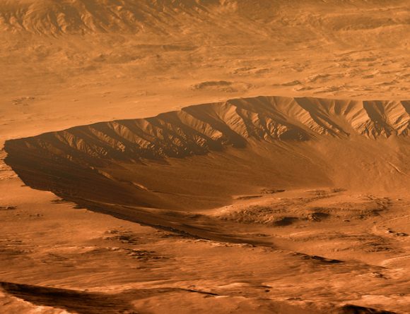
Gasa Crater on Mars. Rendered using Autodesk Maya and Adobe Photoshop. HiRISE data processed using HiView and gdal. Credit: NASA/JPL/University of Arizona/USGS/image editing by Kevin Gill.
Some of the best data around for these purposes come from the HiRISE camera on board the Mars Reconnaissance Orbiter. Data known as Digital Terrain Model (DTM) files, the HiRISE DTMs are made from two or more images of the same area of a region on Mars, taken from different angles.
DTMs include information such as elevation information that is particularly valuable in being able to create images that appear to be taken from the surface of Mars or to create flyover videos.
So, just how do you go from this DTM image from HiRISE:
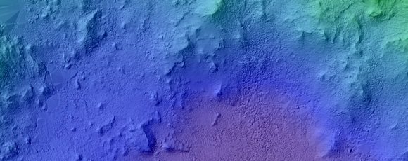
DTM image of the Central Peak of Elorza Crater on Mars. Credit: NASA/JPL/University of Arizona/USGS
To this amazing image?
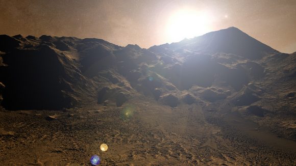
Martian sunrise over the Central Peak of Elorza Crater. Rendered using Autodesk Maya and Adobe Photoshop. HiRISE data processed using HiView and gdal. Credit: NASA/JPL/University of Arizona/USGS/image editing by Kevin Gill
I'm going to let Kevin explain it:
To prep the data, I use Photoshop (to convert the JP2 file to a TIFF), and then standard GIS tools like gdal (Geospatial Data Abstraction Library) to create textures for 3D modeling. Using Autodesk Maya, I input those into a material as a color texture (orthoimagery) or displacement map (the DTM data).
I connect that material to a NURBS plane (sort of like a polygon mesh) that is scaled similarly to the physical properties of the data. I set up a camera at a nice angle (it takes a number of low-resolution test renders to get an angle I like) and let it render.
Then I just pull that render into Photoshop where I have a series of monochromatic color tints which gives the image it's Martian feel. For the sky, I use either a sky from a MSL MastCam image or one that I took outside with my cell phone. If I'm using a sky I took with my cell phone, I'll adjust the colors to make it look more like it would on Mars. If the colors in the image are still boring at this point, I may run a HDR adjustment on it in Photoshop.

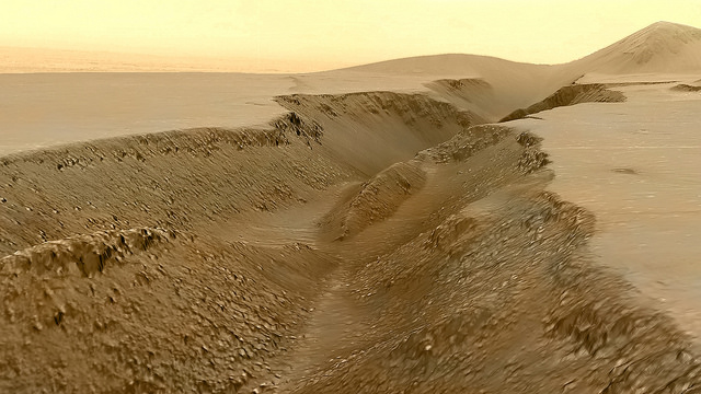
Fissure in the Cerberus region. This false color view of a volcanic fissure in the Cerberus region of Mars was created using a digital terrain model (DTM) from the High Resolution Imaging Science Experiment (HiRISE) camera aboard NASA's Mars Reconnaissance Orbiter. The horizon was taken from Curiosity Mastcam imagery. Credit: NASA/JPL-Caltech/University of Arizona/ image editing by Kevin Gill.
What all this means is that you can create all these amazing view, plus incredible flyover videos, like this one Kevin put together of Endeavour Crater:
Or you can have some fun and visualize where the Curiosity rover is sitting:
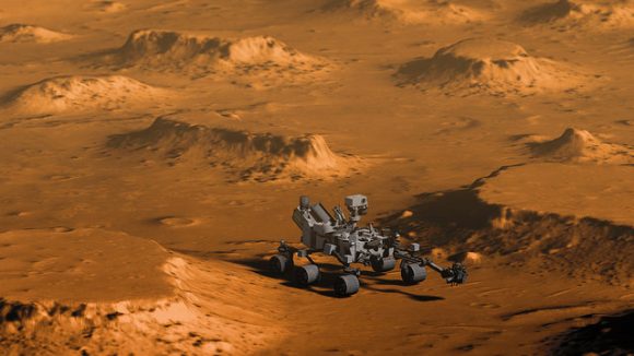
Doin' Science with Curiosity. Created using HiRIST DTM and Ortho data and NASA model of Curiosity. Rendered using Autodesk Maya and Adobe Photoshop. Curiosity Model: Brian Kumanchik, NASA/JPL-Caltech. Image editing by Kevin Gill.
We've written about this type of image editing previously, with the work of the people at UnmannedSpaceflight.com and others. Of course, the image editing software keeps improving, along with all the techniques.
Kevin also wanted to point out the work of other image editing enthusiast, Sean Doran.
"Sean's work is resulting in views similar to mine," Kevin said via email. "I know he's using a process very different from mine, but we are thinking along the same lines in what we want out of the end product. His are quite impressive."
For example, here is a flyover video of the Opportunity rover sitting along the rim of Endeavour Crater:
You can see more of Sean's work on his Flickr page
And you can see all of Kevin's Mars DTM images at his Flick page here.
Thanks to Kevin Gill for sharing his images and expertise!


No comments:
Post a Comment